

GERMAN ALPS
OVERVIEW
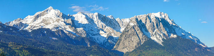
The Alps are a majestic mountain range that extends across Central Europe and includes parts of Germany, Austria, Switzerland, Liechtenstein, Monaco, Italy, France, and Slovenia. In Germany, the Alps are located in the southern region of the country and are known as the Bavarian Alps. The Alps are Europe's most prominent mountain range, with a length of 1000 km and a width between 120 and 250 km. The highest peak in Germany, the Zugspitze, is located in the Bavarian Alps and stands at a towering height of 2,962 meters. The Bavarian Alps are a popular destination for winter sports enthusiasts and mountain climbers.
From a climatologic perspective, the Alps play an important role in protecting Europe from storm systems like tornados, as they block the masses of warm air from the south from the cold ones in the north.
GEOLOGICAL FORMATION
The Alps are a stunning example of the dynamic and ever-changing nature of the earth's surface. From a geological perspective, the Alps are relatively young and are the result of the Alpine orogeny, which occurred approximately 44 million years ago. During this time, the African and European tectonic plates collided, leading to the formation of the Alps.
The Alps are formed mainly of sedimentary rocks that were originally part of the seafloor. These rocks, which include limestone, sandstone, and shale, were deposited on the seafloor during the Jurassic and Cretaceous periods, which spanned from 201 to 66 million years ago. As the African and European plates collided, the seafloor was uplifted and thrust upward, forming the towering peaks and rugged terrain that we see today.
One interesting feature of the Alps is that they emerged from a former ocean named Tethys Ocean. This ancient body of water existed between the supercontinents of Gondwana and Laurasia and was eventually consumed by the colliding plates. Today, remnants of the Tethys Ocean can be found in the form of limestone deposits and other sedimentary rocks that make up the mountains.
The Alps were further modeled by Alpine glaciation and expanding ice tongues, which occurred during the Quaternary period, approximately 2.6 million years ago to the present day. During this period, the climate was much cooler, and the mountains were covered by vast sheets of ice. As the ice expanded and contracted, it carved out valleys and shaped the mountains' distinctive features. Today, evidence of the Alpine glaciation can be seen in the form of glacial lakes and U-shaped valleys, which are a testament to the power of nature and the ever-changing landscape of the Alps.
THE ZUGSPITZE - GERMANY'S HIGHEST PEAK

The Zugspitze is the highest peak in Germany, with an elevation of 2,962 meters (9,718 feet) above sea level. It is located in the Bavarian Alps, which form a natural border between Germany and Austria. The mountain is part of the Wetterstein range and is situated near the town of Garmisch-Partenkirchen.
The Zugspitze is a popular destination for hikers and mountaineers, offering stunning views of the surrounding landscape. The mountain can be accessed via several hiking trails, as well as by cable car or cogwheel train. Visitors can also reach the summit via the Zugspitze Glacier cable car, which provides a breathtaking view of the glacier and surrounding mountains.
The mountain is known for its unpredictable weather, which can change quickly and dramatically. It is advisable to check weather forecasts and come prepared with warm clothing and appropriate equipment. In winter, the mountain is a popular destination for skiing and snowboarding, with several ski resorts and slopes available for visitors of all skill levels.
GERMANY'S REMAINING GLACIERS
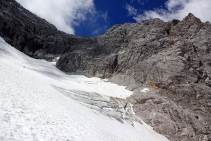
Germany has only four remaining glaciers left, with one being lost in 2022 due to the effects of climate change. Glaciers can typically only be found in high mountain regions, such as the Alps, and are not only a natural wonder, but also a popular tourist attraction and source of revenue.
The formation of glacial ice is a slow and complex process that begins with the compression of snow over an extended period. Fresh snow is compressed into firn (corn snow) during the winter months. If the climatic conditions are right, the firn will not melt, and a new layer of snow will cover the older layer. Over time, the firn is further compressed into hard bluish and greenish glimmering ice, which is called a glacier.
Glaciers are important to the environment and play a crucial role in regulating the Earth's temperature and water cycle. They act as natural reservoirs, storing large quantities of water that are slowly released into rivers and streams over time. Additionally, they reflect a significant amount of sunlight back into space, helping to cool the Earth's surface.
Despite their ecological importance, glaciers are facing a significant threat from climate change. Rising temperatures and changing precipitation patterns are causing glaciers to melt at an accelerated rate, leading to a loss of freshwater resources and a rise in sea levels.
Germany's remaining glaciers have been reduced to small patches, providing a stark visual of the impact of climate change. The effects of global warming can be seen clearly in these melting glaciers, and forecasts suggest that only the Höllentalferner glacier may survive in the coming decades.
| Zugspitze | Wettersteingebirge | Berchtesgardener Alpen |
|
Nördlicher Schneeferner
lost: Südlicher Schneeferner |
Höllentalferner |
Watzmanngletscher Blaueisgletscher |