

NORTH GERMAN LOWLAND
OVERVIEW
The North German Lowland (German: Norddeutsches Tiefland), is a vast plain region in Germany that stretches from the North and Baltic seas southwards to the foreland of the Central German Uplands (German: Deutsches Mittelgebirge). The North German Lowland is a part of the Great European Plain, and its geographical features were shaped by glaciers in the past.
This lowland region can be further divided into three distinct areas: marshland and coastal areas, moraine regions, and loess regions. The marshland and coastal areas are located along the coastlines of the North and Baltic seas and are characterized by flat, low-lying terrain. These areas are known for their unique flora and fauna and are home to several nature reserves.
The moraine regions were formed by glacial action and can be divided into two categories: newly formed top moraine regions and regions that had been formed by glaciers before the last ice age. The newly formed top moraine regions are characterized by many lakes, which were created by the melting of glaciers and are known as kettle holes. These lakes are popular tourist destinations and offer various recreational activities such as swimming, fishing, and boating. The most fertile soils in Germany can also be found in these areas, making them significant agricultural regions.
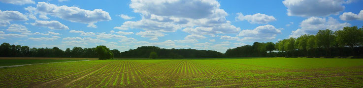
The loess regions spread to the foreland of the Central German Uplands and are characterized by a thick layer of loess soil, which is fertile and ideal for agriculture. The loess regions are also known for their distinct landscape features such as sand dunes and river valleys.
The North German Lowland is home to several large cities, including Berlin, Hamburg, and Hanover, as well as numerous smaller towns and villages. These urban areas serve as important economic and cultural centers, offering a variety of attractions and activities for visitors.
THE MECKLENBURG LAKE DISTRICT
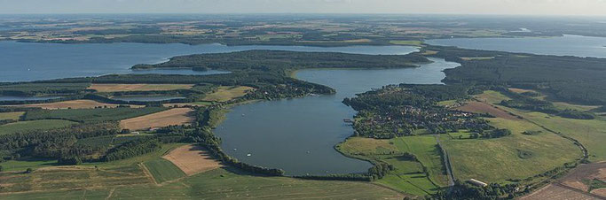
The Mecklenburg Lake District, also known as the Mecklenburgische Seenplatte, is part of the North German Lowland and located in the northeastern part of Germany. It is a unique geographical region characterized by its extensive network of lakes, canals, and waterways.
The Mecklenburg Lake District covers an area of about 5,000 square kilometers and is situated between the cities of Berlin and Hamburg. The landscape was shaped by the last Ice Age, which created numerous glacial lakes and moraines.
The lakes in the Mecklenburg Lake District are spread over a large area and vary in size from small ponds to large lakes such as Lake Müritz, which is the largest one in the region. The lakes are interconnected by canals and waterways, creating a vast network of water that is perfect for boating and water sports.
The canals were built in the 18th and 19th centuries to transport goods and are now used mainly for recreation.
Furthermore, the Mecklenburg Lake District is characterized by its extensive forests, which cover approximately one-third of the region. The forests are home to a variety of flora and fauna, including rare species such as the white-tailed eagle, black stork, and otter. The region is dotted with several nature reserves and national parks, including the Müritz National Park.
THE GLACIAL SERIES
The glacial series, also known as the glacial cycle, is significant to the North German Plain because it has played a critical role in shaping the landscape of the region. The glacial series describe the sequence of events that occur during an ice age. The glacial erosion, transport, and accumulation stages were responsible for creating many of the landforms that are found in the region, while the deglacial series marked the end of the ice age and the formation of the modern landscape. By understanding the glacial series, one can better understand the geology of the North German Plain and the processes that have shaped it over time.
The series includes the stages of glacial erosion, glacial transport, glacial accumulation, and the deglacial series. These stages are essential to understanding the geological changes that occur during an ice age, including those that have taken place in the North German Plain.
During the glacial erosion stage, ice sheets and glaciers move across the landscape, causing erosion of the underlying rocks and soils. This process leads to the formation of features such as U-shaped valleys, cirques, and aretes. In the North German Plain, this stage was responsible for the creation of the Baltic Sea basin, which was carved out by glaciers moving from the Scandinavian Mountains.
The glacial transport stage involves the movement of rocks and sediment by ice sheets and glaciers. As they move, they pick up sediment and rock, which is then deposited as moraines, drumlins, and eskers. In the North German Plain, these deposits can be found in areas where the ice sheets and glaciers advanced and retreated, such as the terminal moraines found along the southern edge of the Baltic Sea basin.
During the glacial accumulation stage, snowfall accumulates and compacts over time to form ice sheets and glaciers. This stage is responsible for the growth of the ice sheets and glaciers that covered much of Northern Europe during the last ice age. In the North German Plain, this stage was responsible for the formation of the ice sheets that covered the region.
The deglacial series marks the end of the ice age and the retreat of the ice sheets and glaciers. This stage is responsible for the formation of features such as glacial lakes, meltwater channels, and outwash plains. In the North German Plain, this stage was responsible for the formation of the meltwater channels and outwash plains that characterize the region.
EAST FRISIA
East Frisia, or Ostfriesland in German, is located in the northwest of Germany. It is a coastal region that is bordered by the North Sea to the north and the Netherlands to the west. The landscape of East Frisia is characterized by vast marshlands and flat plains. The region is crisscrossed by numerous small streams and rivers that eventually flow into the North Sea. The coastline is dotted with sandy beaches, dunes, and small islands. One of the most prominent features of East Frisia is its strong cultural identity. The region has a distinct dialect of Low German, which is still widely spoken in the area. The region is also known for its tea culture. East Frisia havs a long tradition of tea drinking and is home to several tea museums and shops.